Friday, May 30, 2014

p26
My sister and her husband drove me to Point Lookout at the southern tip of Maryland where the Potomac empties into the Chesapeake.  At the end of the land, sits a lighthouse atop the keepers house built in 180.  A fence keeps the public away from it, except on a few select dates each summer.  On the state park land a civil war hospital and prison had been located.  After touring the museum we drove nearby to get a look at the Point No Point Lighthouse (yes that's its real name) located 2 miles out in the Chesapeake.  It was built in 1905 on top of concrete caissons.  An auction was planned to sell the lighthouse top to any town to use as a museum on land, but the nearby navy base objected as their planes use it as a boundary marker from the air.  So today it still sits, now just a marker.
We drove to Silver Springs, MD (near DC) to visit our 91 year old uncle.  He paints with steady hand on canvas.  He had always been good at drawing and started painting in acrylics in his older years.  We should be so lucky to be so sharp and talented at 91.

Saturday, May 24, 2014

p25
At Great Falls Tavern Visitor Center you can take a ride on a canal boat.  They move the boat into the lock by mule, raise the level of the water like they did in the 1800s and the mules pull it down the canal.  Canal boats don't have to turn around, being pointed at both ends, so mules just turn around and bring the boat back to the lock where it is lowered and back to where the dock is to load and unload people.
The falls are located here and you can see the falls from the bank of the river near the center.  I cycled the towpath 15 miles into Washington DC where I caught a bike trail to the Lincoln Memorial.  I cycled around the mall to the Jefferson Memorial, WWII Memorial, and the FDR Memorial. I cycled back up the towpath to Great Falls, a total of 40 miles.


p24
The next day I went back to Harpers Ferry and cycled the C&O Canal towpath. The towpath is level, except where there is a lock where the trail changes elevation by about 10 feet.  Cycling the towpath is like riding in the woods as the canal and the ground between the canal and towpath have returned to nature.  By the time I got back to the truck I had gone 40 miles.

p23
Harpers Ferry, WV is where the C&O Towpath and the Appalachian Trail intersect.  It is where the Shenandoah River empties into the Potomac River and in 1747 Robert Harper operated a ferry across the rivers, henceforth, Harpers Ferry.  My wife's maiden name is Harper and her family can be traced back to colonial days in  West Virginia when it was part of Virginia.  The Appalachian trail goes through the mountain above town, then through town, then across a footbridge over the potomac to the C&O towpath for a couple of miles before splitting from the towpath.  I climbed the trail up hill as it passed the Jefferson Rock.  Thomas Jefferson climbed on top of this rock to overlook the area. 
Mills were built along the rivers in the 1700s and 1800s.  One such mill used the power of the river to turn lathes at the US Armory to make rifles and ammunition for the new US government. In 1859 abolitionist John Brown attempted to raid the armory to get weapons for a slave revolt, but failed.  In 1861 the Confederates attacked the Union arsenal.  The Union soldiers burned the armory down to keep the weapons from the confederates.  Eight times during the civil war Harpers Ferry changed hands, between Union and Confederate troops.  With frequent floods or dry spells, the Mills would not be working all the time.  Today all that remains of the mills are the foundations along the river.  All the old buildings along Shenandoah Street have been restored and are part of the Harper Ferry National Historic Park.  A free shuttle takes you from the park visitor center to the 3 blocks of buildings that are museums in each building.  Rangers are available for questions. 


p22
I climbed the Washington Monument, the first one that is, in Boonsboro, MD.  In 1827 Boonsboro, MD built a monument to George Washington on top of the mountain near town. During the civil was the union used it as a lookout during the battle of South Mountain.  During the 1930s it was restored.  It is built of bluestone which is laying there on the mountain.
Today you can tour the museum that covers the monument and the civil war battle, then hike up the mountain to the monument.  You can climb the 40 steps to the top for a panoramic view of the valleys and mountains.

p21
Because of waterfalls the Potomac River is not navigable by boat west of Georgetown (Washington, DC).  So in 1828 the C & O canal was dug along the Maryland side of the Potomac.  By 1850 the canal had reached 185 miles to Cumberland, MD, but in the 22 years it took to build, railroads had started to be built and actually beat the canal to Cumberland by 8 years.  Cumberland was a coal mining area and coal was the main cargo to go down the canal.  Mules would walk a tow path that was located between the canal and the Potomac, pulling the boats. There were 72 locks along the 185 mile canal.  The mines were mined out by 1920 and the canal closed in 1924 after a damaging flood.
Today the canal is a national park and you can cycle the towpath.  The canal is missing in a few sections, but is there in most of the park.  In some sections there are aqueducts where the canal goes over a creek that empties into the Potomac.  At the start of the towpath in Cumberland is a museum about the canal and Cumberland.  I cycled the towpath for several miles with my mountain bike as the path is not paved but is crushed gravel.  Since the canal and land between the Potomac and the tow path is national park, nature has taken over with birds and other animals numerous among the many trees.  Tow groundhogs watched me pass, but ran away when  I stopped to chat. In the other direction from the museum there is a bike trail following a railroad northwest  through the Allegany mountains 150 miles to Pittsburgh.  I cycled that trail for several miles also.

p20
gettysburg national military park has a large museum with a film and cyclorama.  I stopped by the battlefield on my way from east of Lancaster, PA to high in the mountains near Cumberland, MD.  The museum was so interesting that I never had the time to do the shuttle to the Eisenhower home.  I would like to go back some day and spend the entire day there and ride my bike aroun d the tour of the battlefield and see the Eisenhower home.  As I was leaving the area I did stop and take a picture of Culp's hill (my mom's maiden name - all her ancestors lived in central PA back to colonial times) from cemetery hill.  With the map you can follow the 3 day battle through the hills.

Saturday, May 17, 2014

p19
Valley Forge National Military Park is an ideal place to ride your bicycle as it has miles of bike paths over rolling hills.  Unfortunately a rainstorm made it impossible on the day I was there.  So after seeing the museum  and watching the movie I drove around part of the park where they have reconstructed timber huts like the soldiers built in the winter of 1777-78, Washington's headquarters, redoubts with cannons, and a memorial and statue.

The next day was drier and I cycled through the hills of central Pennsylvania from the campground to Intercourse and Bird-in-Hand (yes these are names of two towns) for a round trip of over 33 miles.  I had to maneuver around horse manure along the low traffic farm roads.  The Amish have two types of horses, thorobred trotters for their buggies and large husky horses for the plows.  Menonites use tractors and trucks.  I saw many horses and buggies on these roads as well as the road next to my campsite. Once I heard a horse and buggy gaining on me from behind as we were going up a hill. I pulled over to the side and told the Amish in the buggy that the horse was much stronger on the hills than I.  They laughed and waved. On the way back I was passed by a young Amish lady on a bicycle.  She had a long skirt on. The bike had fenders, was heavy than  my bike, and she had a box of b read on the back.  For miles I tried to catch her.  Finally just before the campground going downhill, I caught her and told her she was in excellent shape, she laughed obviously enjoying the competition.


Friday, May 16, 2014

p18
After purchasing your ticket on the New Jersey side, a ferry takes you to Ellis Island, then to Liberty Island.  Ferry times are posted so you don't have to rush and can take your time at each place.  The statue of liberty was completed in 1886 and was restore in time for the centennial in 1986.  You can climb to the top of the pedestal (178 steps) as I did.  A museum is on the base of the pedestal and contains the old copper and colored glass flame and torch.  Originally the statue was a lighthouse as the torch was lit each night by electricity making it the first lighthouse in the country lit by electricity.  Eventually it deteriated  and was replace by a gold painted flame on the torch during the restoration. The statue is 151 ft to the top of the flame.  The pedestal is 154 ft for a total of 305 ft ground to flame.  You can climb to the crown (another 152 steps- totally 330 steps) if you have a pass.  The waiting list is over 6 months long because only a few people are allowed on the stairs at a time.  Before you get on the ferry you have to go through a security check like at the airport.  Then at the statue to get into the pedestal you have to go through another security check and any bags have to be put into a locker. On the ferry back you get a good look at the new tower in Manhattan that was built to replace the World Trade Center towers.  The top of it was in the low clouds that day.


p17
From 1892 to 1924 immigrants arriving on ships, passed by the Statue of Liberty on their way to Ellis Island for processing.  They were given a medical exam and their passports were checked for any known criminals.  Some were rejected because of illness or legal reasons.  Some were sent to a hospital to recover.  Sometimes babies were born on Ellis Island.  The first wood main buildings burned down in 1897 with a lot of records lost.  A temporary building was used until a new main building was opened in 1900.  So if looking for relatives names on the Ellis Island website that came over before 1900 you probably will not find it.  Today the main building is a large museum.  The American Family History Center at the museum has computers for you to look up names.  An employee helping people at the center told me I would probably find nothing, but when I got home go to castlegarden.org where any found information prior to 1900 is being put on.  My dad's father came over around 1897.  His mom came over sometime after that from Slovakia(Austro-Hungary).  They met in  Pennsylvania and were married in 1902.  After people were approved to enter the country they were put on a ferry that went to a large train terminal on the Jersey seashore.  The terminal is closed and in disrepair.  Workers were working on repairing it from Hurricane Sandy damage.  Plywood covered parts of the roof.  In 1924 consulates started processing people in their own countries and given visas so the need of Ellis Island for processing became unnecessary.  From 1924 to 1954 Ellis Island was used as a deportation center, hospital, and coast guard.  It closed in 1954 and opened as a museum in 1990.

p16
Fort Hancock was built around the Sandy Hook lighthouse on the northern part of the peninsula in 1890.  When it was closed in 1974 everything was left and the base was given to the National Park Service.  During WWII it went from 800 personnel to 12000.   The fort had batteries of guns, cannons, and mortars.  In the 50s and 60s the guns were replaced by Nike missles.  I walked around most of the base, and the concrete batteries are still there, as well as over a dozen large homes, several smaller ones, and barracks, plus other buildings.  A few of the buildings have been leased.  The coast guard which has a station at the northern most section leases a couple old buildings, plus has their own newer ones.  Since Hurricane Sandy flooded the entire land mass and the ocean and the bay became one, many of the empty buildings are in bad need of repair, new roofs, etc. The park service is trying to find people interested in leasing any of the large homes as bed and breakfasts, but the restoration by the leasee would be expensive.


p15
Sandy Hook Lighthouse is at the end of land shaped like a hook and is sandy.  This is the oldest lighthouse you can climb, built in 1764 when New Jersey was a British colony.  It is 103 ft tall with 104 steps and celebrates 250 years as an active light in June, today maintained by the coast guard.
Its very thick brick walls (29 ft thick at the base and 15 ft thick at the top) and iron stairs have withstood many storms and hurricanes. Hurricane Sandy in 2012 flooded the entire peninsula, but it didn't effect the light.  However the light keepers house, which is a museum, has some damage which is being worked on.  Many lighthouses have a problem with beach erosion, but Sandy light is now further from the ocean.  When built it was 500 ft from the beach, now it is a mile and a half.  Climbing is free accompanied by a ranger and you get to go in the light room.  While most lights are on and off for specific seconds, Sandy Hook is on at all times. 
In 1897 my grandfather and his sibling( all didn't come over the same year) would have seen the lighthouse as their ship came into Ellis Island as they immigrated from the Carpithian mountains in Slovakia(Austro-Hungary).

p14
the 64 ft Navesink Twin Lighthouses are atop a 200 ft steep hill in Highlands, NJ.  One is Octagon and the other is square, built in 1862 of brownstone with a 320 ft building connecting them where the keepers lived, which is now a museum.  The public can climb the 64 steps of the octagon light.  The view from the top of the light gives you a view of Sandy Hook and its light and the New York City skyline.  The day I visited was foggy and low clouds so you couldn't  see NY.  Climbing is free.  These towers is where Marconi conducted his first wireless experiments.  The towers were the first in the US to use Fresnel Lenses.

Monday, May 12, 2014

p13
Cape May NJ is located on the southern tip of New Jersey with the Delaware Bay to the west and the Atlantic Ocean to the south and east. The Cape May lighthouse is located in the Cape May State Park. The beacon is still maintained by the coast guard.  I cycled to the light as the public can climb the 217 steps to the top.  It was built in 1859 of brick with iron stairs and is 158 ft tall.  On the beach near the lighthouse is what is left of a WW II bunker that had a battery of guns on it to protect the Jersey shore.  The guns were removed by the end of the war leaving the concrete bunker.  Also nearby is a WWII concrete round watch tower that was used as a look out for enemy subs.  By the end of the war it was no longer used and then eventually became a museum open on weekends.
Cape May is still a summer resort with many large Victorian homes, some used as bed and breakfasts.  North of Cape May, the county has been moving very old homes and  from around the county to create the Historic Cold Spring Village.  It is open to the public during the summer.  Homes as old as 1817 are there along with a railroad station, country store, and an old jail.
Even though it wasn't open the ladies at the visitor center/museum told me I could walk around and look in the windows, as the doors were locked until they open soon for the summer.  The homes have been furnished with antiques.


p12
The Concord Lighthouse in Havre de Grace, Md where the Susquehanna river empties into the Chesapeake bay is unique in that it is made all of granite, even the stairs.  It has lasted almost 200 years, having been built in 1827.  It is open on weekends to climb for free.  Most lights that you can climb require an admission of a few dollars to help pay for the upkeep.  It is only 36 ft high with only 35 steps. The last 8 steps are an iron ladder and the lenses are still there. The keepers house has been turned into a free museum.  Across the street is a maritime museum covering the crabbing and fishing industry of the past 200 years of Havre de Grace.
Elk Neck State Park is on the end of a peninsula with the Elk river on the east side and the Chesapeake bay on the west.  At the southern tip is the Turkey Point Lighthouse.  The next morning I cycled the 5 miles from the campground to the light over many steep hills.  The last mile is over a gravel road which I luckily took my mountain bike instead of my road bike.  The lighthouse sits on a hundred foot high bluff where the Elk river meets the Chesapeake.  The light was built in 1833 and the coast guard decommissioned the light in 2000, then deeded the land to the state park.  The light comes on daily and is powered by solar powered batteries.  the wood stairs were rebuilt in 2007.  The public can climb the 32 ft high light on weekends.  With binoculars you can see the Concord light.  In the 1800s all light keepers had to haul the whale oil or lard or kerosene up the steps at night, then work in their vegetable gardens, feed the chickens, milk the cow or goat, before going to bed.  In their spare time they fished for food.


Friday, May 9, 2014

p11
The Piney Point lighthouse was built in 1836 and was used until decommissioned in 1964.  It is only 35 ft tall (about 4 stories). Chesapeake Bay lighthouses all had bells that they would ring when it was foggy. The number of seconds between each ring of the bell told a ship which lighthouse I was.  The tower that held the bell next to the lighthouse is no longer there.  Next to the lighthouse is the keepers house and two museums.  The one museum contains old long boats used for crabbing, clamming, and for oysters.
Nearby is the Historic St Mary City. It was settled in 1634 and became the first capital of Maryland until 1695 when it was moved to Annapolis. Eventually the original site of St Mary City became farmland.  As archeologists found the remains of foundations, they were able to build replica buildings, creating a village of the 1600s. An inn, a printers house, farmers house, the chapel, a barn,  the state house, and others have been rebuilt. Guides in period dress speak to you at most buildings. A exact working replica of one of the ships used by the colonists has been built and is occasionally sailed.  Guides in period dress show you around the ship.


Thursday, May 8, 2014

p10
The Drum Point lighthouse was built in 1883 at Solomons, MD, just off shore on screwpiles. Eventually the Chesapeake Bay created a larger beach and the sand was up to the lighthouse.
It was decommissioned in 1962 and moved to its present location next to the Calvert Marine Museum in 1975.
The light is octagonal shaped and the first two stories are open with no walls. The third and fourth stories are living quarters and office.  The light is on the fifth floor.  The museum gives a tour of the light, taking you to the light room. The living quarters are furnished in old style furniture and the outhouse is still there.
The museum covers the boat building days of Calvert County, the agriculture and the seafood industry, and has many fossils found in the county.

Wednesday, May 7, 2014

p9
The /First Landing State Park is on the Chesapeake Bay beach. My campsite was next to the dune and trees are between campsites, so you don 't see the next campsite.  Rabbits are everywhere in the park.  They ignore all the navy fighter jets and chinook helicopters noisily flying  overhead. Ft Story is next door to the park and Norfolk Naval base is nearby.
At Ft Story there are 2 lighthouses 350 ft apart. Old Cape Henry lighthouse was built in 1792.  It was the first lighthouse financed by the new US government.  It was built on a 56 ft high sand dune 500 yards from the beach, so you have to climb 75 steps to get to the lighthouse.  Since erosion has exposed the foundation, you have to climb 14 more steps to get to the base, then 102 steps inside the lighthouse for a total of 191 steps.  From the base the lighthouse is 94 ft high, but over 150 ft fromm the base of the dune,  making it almost as tall as the new one.
In 1881 it was felt that the old lighthouse would not last, so the new Cape Henry lighthouse was built of iron sides.  After sitting idle for years, the old lighthouse was eventually restored and the public could climb the light.  The new light is still operational and operated by the coast guard, but is not open to the public.
After cycling to the lighthouses,  I cycled south to the boardwalk on Virginia Beach, then took it along the beach to the end, then back to the park, riding around the park, before heading back, for over 30 miles.


Saturday, May 3, 2014

p8
I cycled to the Cape Hatteras Lighthouse on my road bike.  Painters were on a platform like window washers use on high rises, painting the lighthouse.  It is the tallest brick lighthouse in the country at 208 ft and 257 steps.  Fifteen years ago they moved the lighthouse 2750ft to get it further away from the beach.  At the museum it shows how they slid it on rails to accomplish it.
All  lighthouses give a light that lasts a certain number of  seconds, then off a certain number of seconds.  The light intervals tells a ship which lighthouse it is at night.  The pattern that it is painted tells which lighthouse it is during the day.
After climbing the lighthouse I cycled further south along hwy 12, the only north-south road along the outer banks.  The further south I went the worst he road got.  Sand, rock, or cracked asphalt made riding on the shoulder impossible, making me ride the white line, much too close to cars going 55.  I eventually turned around and headed back.  I cycled over 40 miles, but it felt like more (it must have been that 208 ft hill I climbed).
While riding I watched a deer eating a bush, mallards waddling along, and a turtle being slow.  These things you miss when in a car.  I also saw several possums, but they were dead and I had to cycle around them.

Friday, May 2, 2014

page 7
the outer bank barrier islands in North Carolina can get windy.  When the wind is strong and the surf is strong sand is blown off the dunes and on to rt. 12 in the sections where an island is narrow with the dune next to the road and marsh on the other side. As I drove down the road bulldozers were working pushing sand back away from the road. Last night 25 mph winds rocked my camper and rocked me to sleep.
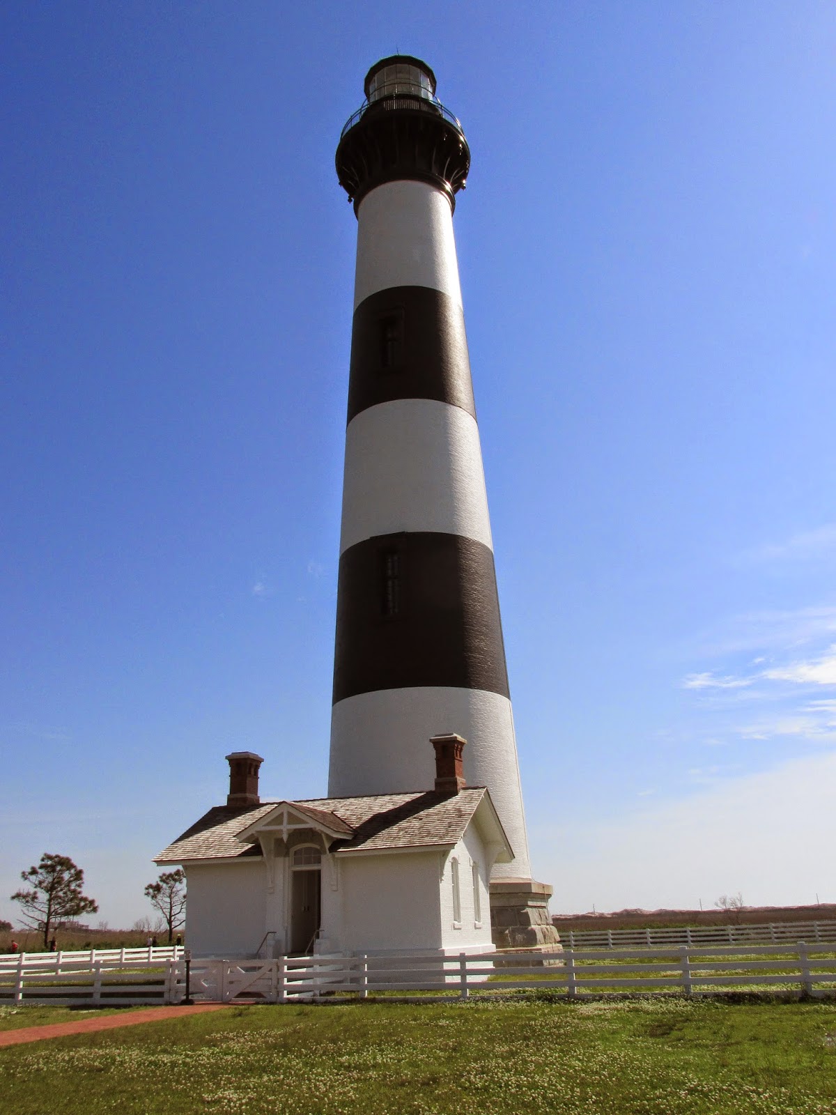
The rangers at the Bodie Island Lighthouse give a tour and an informative talk every 2 or 3 flights up the lighthouse. These talks give climbers a chance to rest on the way up as it is 214 steps and 164ft tall.  Each ranger climbs several times a day, so each ranger was slender. At the top it was very windy, but the rangers hat never blew off (she had it pinned to her hair).
A few miles north of the lighthouse is the Wright Brothers Memorial at Kill Devil Hill, near Kitty Hawk. The spot where they took off is marked by a stone marker and also where each of the first four flights landed. The fourth was the longest at over 800 feet and 59 seconds. Inside the museum is  exact working replicas of the first glider and their first plane.  A ranger gives a talk and moves the controls to show how the wings flex and the rudders turn.  On top of the hill is a monument to the Wright brothers.  They took off on the flat ground, not the hill, off a wood rail. At the end of the rail it became airborne. The park service reconstructed the 2 wood buildings the Wright brothers built to work in at the sand dunes.
On Roanoke Island is a museum about the lost colony.  The English colonized the island in 1585 - 1587.  On a return supply trip the colony was found abandoned and no trace of survivors. The museum had a replica of one of the ships used by the colonists to travel to the new world.  You are allowed to walk around the ship as guides tell you about the ship.

page 6